

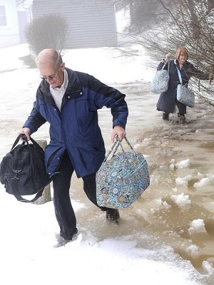


Sam and Becky Longanacre evacuated their home on Violet Lane in Beaver carry some luggage through some high water.
BECKLEY, W.Va. — Schools throughout The Register-Herald readership area were hoping for a break from the extreme weather Wednesday, but as creeks began rising from the heavy rainfall and melting snow, roadways started to flood all across southern West Virginia, prompting Wyoming County to close schools before students arrived, and other counties to dismiss early.
Meteorologist Ken Batty said the rain was expected to change to sleet and wet snow around midnight, and approximately 2 inches of snow will likely accumulate by 7 a.m. during the Thursday morning commute.
“The temperature will drop, and with all the water still coming off the mountains, we’re expecting a great crop of icicles on the cliffs. Even though there will only be a couple inches of snow then … anything untreated can be icy.”
Temperatures will hover in the 20s Thursday, with snow continuing to fall across the region through the afternoon.
Batty said most of the snow will fall between 7 a.m. and noon, with a total of up to 6 inches by the time the storm is over.
Southern West Virginians won’t be receiving the brunt of the snowstorm this time around though — Batty said the Ohio Valley will be hit much harder this time…